Doctoral Degree Program Geodesy and Cartography
Branch of study Geodesy and Cartography
Introduction into the issue of the applied mathematics and numerical methods, mathematical statistics,
theory of errors in the geodesy and cartography, theory of optical projection in the application on geodesy
and then with the digital photogrammetry, digital cadastre of real estates and digital cartography. Appropriate
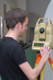
attention is also paid to the theoretical bases of the engineering geodesy, the most modern methods of positioning,
technology of the space geodesy, navigation and information technologies including GIS. Emphasis is placed also
on study of physical characteristics of the Earth body.
After termination of study, a graduate will be able to carry out interdisciplinary research work e.g. in specialization
of theoretical and engineering geodesy, to build geodetic fields, to process geodetic information in the automatized way,
to design and create branch GIS, to apply distance research of the Earth and to deal with digital photogrammetry
in connection with the laser scanning, to use possibilities of the digital cartography and robust map servers and also
to work in the area of the most extensive information system in the ISKN state administration.
A graduate of the doctoral studies will find an employment according to his professional profile not only in the resort
of the geodesy and cadastre, but also in all the branches using geoinformation for its decision-making and control activities,
as e.g. in the area of environment creation and protection, water management, logistics, integrated protection systems,
landscape planning etc.
Graduates of the doctoral studies will also find employment as young lecturers with perspective of their further
professional and pedagogic growth.